Kinda MipMapping, but different

Discussions regarding Materials, Material-Compounds or Shaders, etc.
Post Reply
User avatar
sant0s
Posts: 353
Joined: 05 Sep 2011, 22:57
Location: São Pedro de Moel

Kinda MipMapping, but different

Post by sant0s » 04 Sep 2013, 10:54

Hi,
actually MipMapping is for the same texture but for different resolutions, right?
Means, as closer I get, the higher resolutions gets choosen, but the texture is the same.

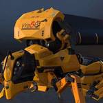
But what, if I have something like in the image I attached?
Is there a clever and fast way to get that to work?
Because I have to go much much closer as in the example and sometimes its quite enoying couse the image is HUUUGE :)

The tiles are always tiled in horizontal and vertical one time and getting better resolution as closer I get (the example image does not show final resolution, just scaled it ^^).

Right now I fit the explicit projection to get what I want - but it is not realy accurate as closer I get.
I thought, I could just use the same projection as the original sphere has, extract the polygon (in example the slected one) and somehow manage the correct projection in the texture itself...
Dont get it :)

Any ideas?

Thx alot!
Attachments
tiling.jpg

NNois
Posts: 754
Joined: 09 Jun 2009, 20:33

Re: Kinda MipMapping, but different

Post by NNois » 04 Sep 2013, 11:59

Hi, sorry i don't get where exactly is your problem...
For me the process is simple.
1.Extract the polygon as you said with the original world map
2.Render map it to a new full projection for this zone
3.In photoshop match your Zoomed portion to this Render mapped zone
4.Your texture is ready to be mapped no ?

If you want you could split by clusters and use a raylenght shader to blend you image by the distance to the camera

User avatar
sant0s
Posts: 353
Joined: 05 Sep 2011, 22:57
Location: São Pedro de Moel

Re: Kinda MipMapping, but different

Post by sant0s » 06 Sep 2013, 09:43

moin :)
first, thx for you answer.

Point is, that I use elevation Data, satellite images, water maps, ect - and all fit together if I layer them.
I get the data from a GIS software that has always square tiling.

The globe on the image has 8*8 subdivisions, the image is made from 64 tiles.
If i zoom to that little, in the image red marked, polygon, I get an Image that would be built from 16384 image tiles if I would cover the complete globe.

To avoid that, we blend different resolutions and, actually, did it in a similar way what you explained.
But its always a mess to fit the elevation data, color map, water map, ect by hand. It somehow works, but I thought, I could somehow do it a more accurate way.

Like in the example image: tiling the closeup image through 128*128 and tell the correct projection position somehow...

Ill create an example scene to show what I mean.

Post Reply

Who is online

Users browsing this forum: No registered users and 43 guests